
The answer is all of the above (and much more).
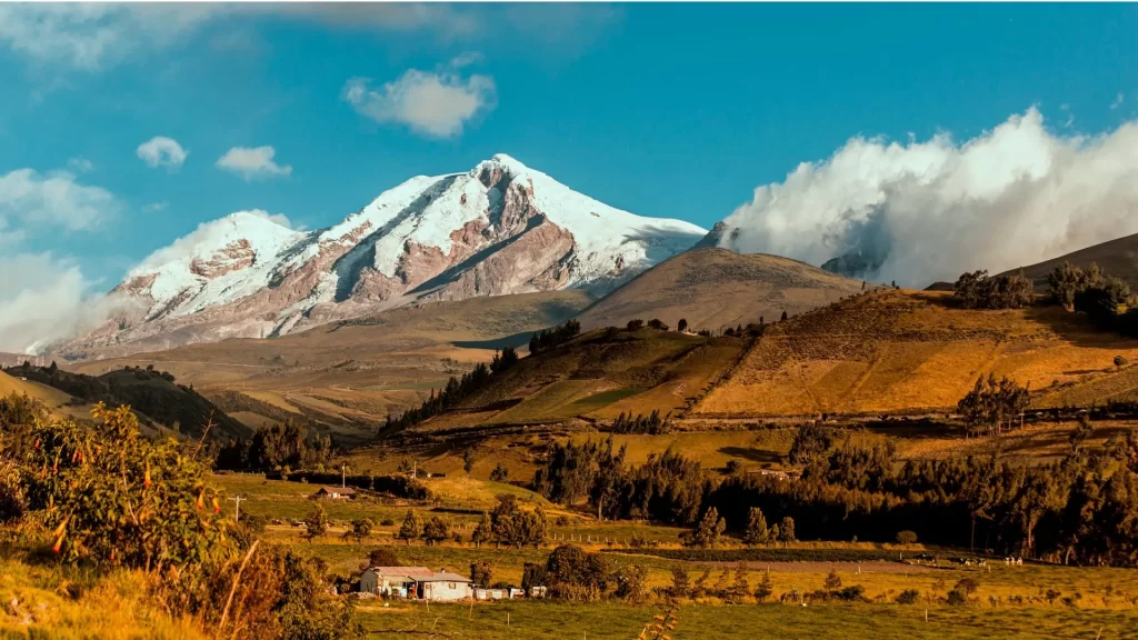
Imagine a ribbon of road stretching south from Quito through Ecuador’s Andean mountain range. On a clear day, giant snowcapped peaks float above green valleys: Cotopaxi, Chimborazo, Cayambe, Antisana, Ilinizas, and Tungurahua, each with its own personality. This stretch of the Pan-American Highway and the secondary roads of the surrounding highlands is what travelers call the Avenue of the Volcanoes.
Is it a road trip? Of course, one of the most picturesque in South America.
Is it a climbing trip? It can be, as world-class mountaineering is available here.
But it’s also something more: a flexible route where you can choose your own adventure and combine easily accessible viewpoints and historic haciendas with active day trips, biking, horseback riding, market visits, waterfalls, and, yes, serious attempts at summiting peaks, if that’s your thing.
Think of it as a canvas. Your interests decide the picture.

Beyond the View: What You Can Actually Do Here
Everyone loves the vistas. But the Avenue of the Volcanoes shines when you match the scenery to an activity level that fits you. Use this at-a-glance guide, then dig into the details below.
Quick Match Guide
| Traveler Type | Core Experiences | Fitness Level | Best Bases |
| Casual Traveler | Scenic stops, short walks, photography, hacienda stays, markets | Easy | Quito, Lasso/Latacunga, Riobamba |
| Active Explorer | Half-day hikes, biking descents, horseback riding, crater lakes, waterfalls | Moderate | Cotopaxi area, Quilotoa loop, Baños |
| Thrill-Seeker | High-altitude climbs (glacier), technical summits with guides | High | Cotopaxi refugios, Riobamba (Chimborazo), Cayambe |

For the casual traveler (road trips and scenic views)
You don’t need climbing gear, or even hiking boots, to be awestruck here.
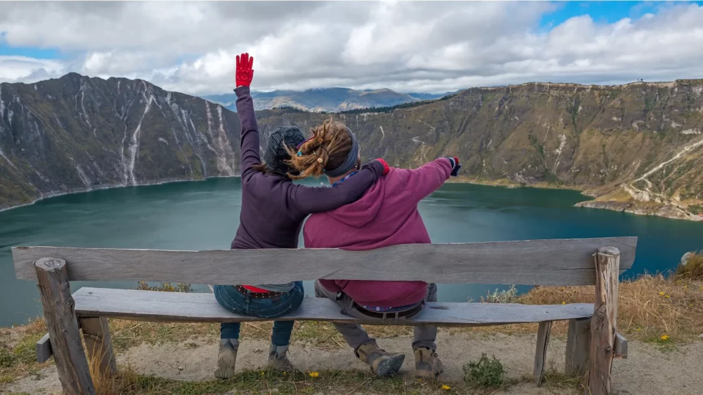
- Laguna Limpiopungo (Cotopaxi National Park): A flat circular walk with wide views of the perfect cone of Cotopaxi. Ideal for photographing sunrise and Andean birdlife.
- Historic haciendas: Sleep in 17th- to 19th-century estates with fireplaces, gardens, and meals made with local produce. Many are located just below volcanoes, with postcard views from the window.
- Moments in towns and markets: Stroll through Latacunga (gateway to Cotopaxi) or Riobamba (gateway to Chimborazo). Plan your visit to coincide with a traditional market day and feel the rhythm of the highlands.
- Panoramic viewpoints: On clear days, your driver can stop at safe viewpoints where you can see the horizon filled with peaks.
Why you’ll love it: Easy days, dramatic backdrops, and cozy evenings by the fire. Maximum beauty, minimum strain.
For the Active Explorer (Hiking & Biking)
Want to move, but not rope up? You’re in the sweet spot.
- Cotopaxi Slopes Hikes: Start around the park’s control points or the parking area below the refuge for pumice-field rambles and views.
- Biking Descents: Ride from high-altitude trailheads down quiet roads with a support vehicle. It’s grin-inducing and mostly downhill.
- Quilotoa Crater (easy add-on): Not strictly on the Avenue, but close. Hike the rim (challenging in parts) or descend to the turquoise lake and paddle a kayak.
- Baños Waterfalls (near Tungurahua): Do the “Route of the Waterfalls” by bike, e-bike, or vehicle, stopping for short walks, zip-lines, and viewpoints.
Why you’ll love it: You’ll be able to feel the landscape (lava fields, moorland grasslands, condors flying overhead) without having to make any technical climbs.
For thrill seekers (climbing and mountaineering)
Ready for thin air and big challenges? The Avenue has legends.
- Cotopaxi (5,897 m): a classic glacier climb. It is usually done before sunrise with crampons, ice axes, helmets, ropes, and a certified mountain guide.
- Chimborazo (6,263 m): Ecuador’s highest peak and the point furthest from the center of the Earth due to the equatorial bulge. Demanding, glacial, unforgettable.
- Cayambe, Antisana, Iliniza North/South: A variety of objectives, from acclimatization peaks to demanding technical routes.
Why you’ll love it: Alpine outings, starry skies, and sunrises above the clouds. But this level requires good physical condition, acclimatization, proper equipment, and professional guides, without exception.

A Matter of Altitude and Safety
You asked, “Is it safe to explore Ecuador’s Avenue of the Volcanoes on your own?”
Short answer: Yes, with smart planning. Here’s how to do it right.
Altitude: your friend that keeps your feet on the ground
- Quito is located at an altitude of approximately 2,850 meters / 9,350 feet. Many travelers feel fine on the first day; some feel dizzy or tired.
- Acclimatize gradually. Plan 1 or 2 quiet days (city walks, short hikes around the lagoon) before engaging in more strenuous activities.
- Stay hydrated, eat light meals, and sleep well. Avoid alcohol on the first night; take electrolytes; if you are sensitive to altitude, consult your doctor about appropriate medication.
Pace is important. “Pole pole” (slowly, slowly) isn’t just for Kilimanjaro.
Volcanoes and climate: respect, don’t fear
- Park notices: conditions on the peaks and access roads can change with wind, snow, or volcanic alerts. A local expert checks daily.
- Dress in layers: the Andean rule: sun at 10 a.m., rain at noon, and wind at 2 p.m. Bring a breathable waterproof jacket, a warm mid-layer, a hat, gloves, sunglasses, and sunscreen.
Drive yourself or with a local guide
- Driving yourself is a good option for experienced drivers, but keep in mind the mountain climate, occasional fog, and gravel roads leading to the parks. Cell phone coverage can be spotty.
- A local guide/driver adds great value: dynamic route adjustments based on weather, choice of safe roads, cultural context, park access permits, and access to trusted suppliers for bike or horse rentals. You’ll get more done with less stress, especially at high altitudes.
Advantages of Responsible Travel SA: Read all itineraries as a guide. All routes and programs are subject to change without notice due to national park policies and regulations, weather conditions, seasonal changes, safety reasons, and wildlife encountered during the trip. Flexibility is the key to the success of any expedition. However, the safety and interests of our passengers are always our top priority.

Your guide to the avenue: how to plan your trip
When to go
- Dry season (approximately June to September): cool air, clearer views of the volcanoes; colder mornings.
- Intermediate season (December-February can be lovely): greener valleys, variable cloud cover.
- Any month is feasible with a flexible schedule and a guide who can “chase the views.”
Where to stay
- Quito: museums, gastronomy, day trips to the north and south.
- Lasso/Latacunga (Cotopaxi area): quick access to the park, classic haciendas.
- Riobamba: ideal for the Chimborazo region and the panoramic views further south.
- Baños: waterfalls, hot springs, viewpoints with swings; lively base for active days.
What to bring (essential)
- Comfortable walking shoes or light hiking boots; trekking poles optional
- Warm clothing + foldable raincoat
- Sun protection (high UV index at altitude): hat, sunglasses, sunscreen with SPF 50+
- Reusable water bottle + electrolytes
- Small bills for entrance fees and snacks; copy of passport for park entrance fees
- Camera with extra battery (the cold drains batteries)
Two sample itineraries (easy to customize)

3 days — Panoramic road trip (low intensity)
Day 1 – Quito → Cotopaxi National Park → Stay at a hacienda
In the morning, transfer to Limpiopungo Lagoon for a walk on flat terrain and enjoy the views of Cotopaxi. Lunch at a rural inn. Check in at a historic hacienda; in the afternoon, stroll through the gardens and enjoy dinner by the fire.
Day 2: Quilotoa viewpoints or the foothills of the Ilinizas
Choose between a scenic drive to the viewpoints of the Quilotoa crater (short walks along the rim; optional visits to artisans) or gentle trails beneath the Ilinizas. Return to the hacienda for a cooking class or horseback riding.
Day 3: Market and monastery → Quito
Stop in Latacunga or at a local market, visit a small monastery or craft workshop before returning leisurely to Quito.
5 days — Active Sierra (moderate intensity)
Day 1 – Acclimatization in Quito
Walk through the old town + viewpoints; early night.
Day 2 – Hike to Cotopaxi + bike descent
Short hike on volcanic slopes, followed by an assisted bike descent (mostly downhill). Night near Cotopaxi.
Day 3 – Quilotoa Crater Trail
Hike along the crater rim with spectacular views; optional kayaking on the lake. Transfer to Baños.
Day 4 – Waterfalls and zip lines in Baños
Bike or car tour along the Waterfall Route; short trails to viewpoints and bridges. Bath in hot springs at sunset.
Day 5: Panoramic views of the Chimborazo Reserve → Quito
Tour of the highlands with camelid sightings and colossal views of Chimborazo. Easy hike near the refuge if conditions permit. Return to Quito.

Honest Logistics: Time, Distance, and Flow
- Quito → Cotopaxi park gate: ~1.5–2 hrs (traffic & weather dependent)
- Cotopaxi area → Quilotoa: ~2–2.5 hrs via scenic highland roads
- Cotopaxi area → Baños: ~2–2.5 hrs
- Baños → Chimborazo Reserve: ~2 hrs; Chimborazo → Quito: ~4–5 hrs
These are realistic door-to-door ranges with photo stops. A local driver keeps you on the prettiest, safest routes—and knows when to swap the order to catch a blue-sky window.
Ready to Stand at the Feet of Giants?
The Avenue of the Volcanoes is whatever you want it to be: a peaceful road trip with golden sunsets and chimneys on haciendas, an active getaway along crater rims and bike-friendly slopes, or a high-altitude adventure above the clouds. You don’t have to choose just one option.
Responsible Travel SA designs the version that suits your pace, comfort, and curiosity, managing permits, park entrance fees, trusted guides, safe transportation, and daily adjustments based on weather and altitude. You bring the wonder, we bring the know-how.
Ready to chart your perfect route among giants? Tell us how you like to travel and we’ll create your trip along the Avenue of the Volcanoes: clear, safe, and unforgettable.

Top Questions About the Avenue of the Volcanoes
1. Is it dangerous to travel the Avenue of the Volcanoes?
The Avenue is a very safe tourist route. With a certified local guide, you can confidently explore its trails and landscapes, as they are experts in a volcanic environment and safety protocols.
2. How do you handle altitude sickness?
Altitude sickness is manageable with proper acclimatization. We recommend arriving in Quito (9,350 feet) a few days early to rest and hydrate before exploring higher elevations. Our guides are trained to help you acclimate smoothly.
3. Do I need to be a professional climber to see the volcanoes?
Not at all. The beauty of this route is that you can get incredibly close to the volcanoes with scenic drives and easy hikes. Climbing is an option for experienced mountaineers, but most of the experience is accessible to everyone.
4. What is the best time of year to visit?
The Avenue of the Volcanoes is a year-round destination. The dry season (June to September) offers clearer views of the peaks, but the rest of the year brings lush, green landscapes and fewer crowds.
5. How much time do I need for this trip?
We recommend at least 3 to 5 days to fully experience the Avenue. This allows you to explore different volcanoes and enjoy a mix of activities without feeling rushed.